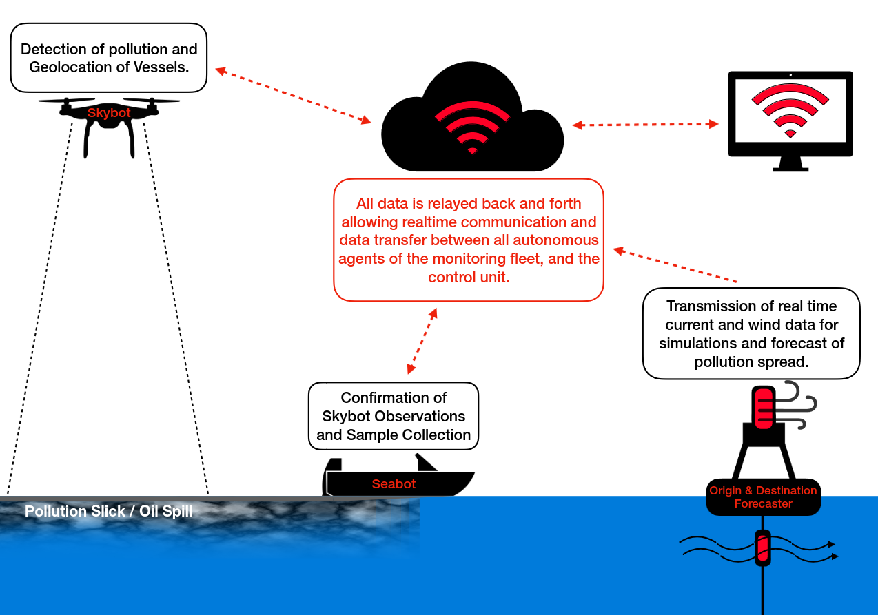
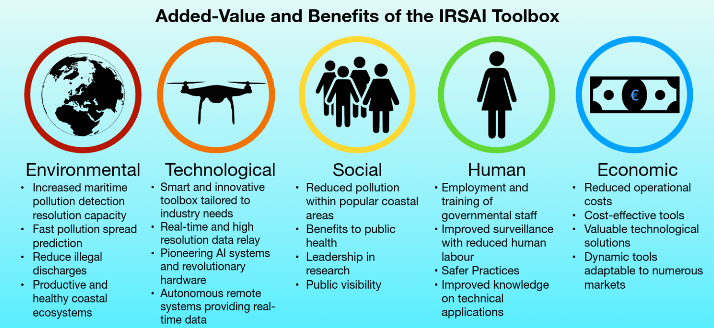
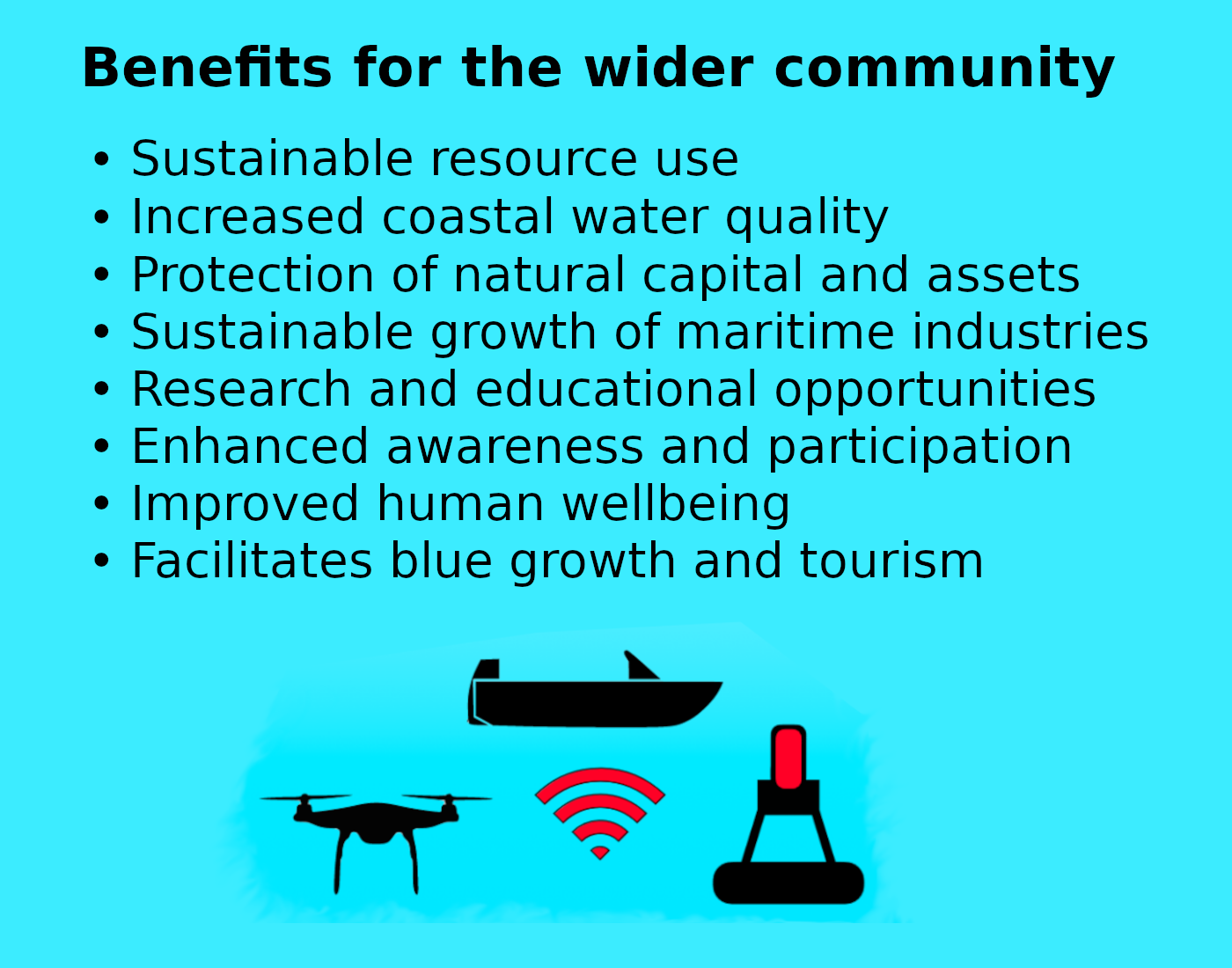
Integrating Remote Sensing and Artificial Intelligence to monitor maritime activities across Limassol Bay

IRSAI Toolbox

drone
SkyBot

A tactical Unmanned Aerial Vehicle to effectively survey Limassol port, anchorage area and wider Limassol Bay area.

drone
SeaBot

A tactical Unmanned Surface Vehicle with a sampler to travel to pollution site, check for oil and collect water samples.

drone
Forecaster

An advanced environmental monitoring system to efficiently collect and analyse spatial pollution data, enhancing the accuracy of pollution prediction and response in maritime areas.

The objective of IRSAI is to enhance maritime surveillance capabilities in the coastal waters of Limassol by integrating multi-agent dual-use technology, both above the water's surface and underwater. Its primary aim is to significantly improve maritime surveillance, enabling effective patrolling of high-risk pollution-prone areas. This system will be dedicated to identifying instances of pollution violations, pinpointing their sources, gathering substantial evidence, predicting the trajectory of pollutants, and guiding timely and appropriate responses by management authorities.

Advancing Maritime Surveillance and Pollution Management

The IRSAI project represents a pioneering effort to introduce and demonstrate innovative technologies in Cyprus for maritime surveillance, pollution detection, and management. These technologies have not been previously demonstrated in Cyprus, and few similar applications have been reported worldwide. By applying these technologies in combination, the project aims to identify their limitations, reduce uncertainties, validate their effectiveness, understand how they work together, and optimize their use in the operational maritime environment. The current Technological Readiness Level (TRL) of these technologies is at a range of 4 to 5, indicating that they are at a stage where they have been validated in a lab environment but have not yet been demonstrated in an operational setting. The IRSAI project seeks to raise the TRL to 7 by demonstrating prototype systems in an operational environment, indicating that they are closer to being ready for practical use.

1

Detection 

For the detection part of spillages, the project relies on processing images and videos from drones using artificial intelligence. The algorithms used for this purpose need to be tailored to the local waters of the eastern Mediterranean, as existing algorithms may not be directly applicable. CYENS, with its expertise in intelligent systems for image and video processing, including deep learning for object detection and tracking, will play a key role in developing and adapting these algorithms.
2

Sampling

Regarding the sampling part with the Unmanned Surface Vehicle (USV), IRSAI will build upon previous USVs developed at the RAS Lab. A new control unit will be designed for the proposed USV, incorporating navigation sensors for this application and an innovative oil detection sub-system. The new controller will be capable of receiving commands from human operators and target positions from the drone, allowing it to operate remotely or autonomously.
3

Forecasting 

For the forecasting part, the project will program a state-of-the-art oil dispersion model to integrate real-time, high-resolution, intelligently processed remote sensing data collected by the drone. While oil dispersion models are available on the market, they typically rely on satellite data, which may have lower image resolution and are not tactical. By combining real-time current data with this model, IRSAI aims to improve and validate the model parameters, leading to more accurate predictions of pollution dispersion in maritime environments.

IRSAI, with its advanced capabilities in maritime surveillance, is poised to revolutionize the way we patrol high-risk pollution areas at sea. By identifying pollution infringements, pinpointing their origins, collecting crucial evidence, predicting trajectory, and facilitating timely responses, IRSAI promises to significantly reduce the prevalence of illegal discharges that often go unnoticed and unrecorded. This breakthrough technology will not only benefit Limassol society by ensuring clean water quality and safe bathing areas but will also bolster the competitiveness of Cypriot enterprises. Through the development of a new commercial service, IRSAI offers the potential to revolutionize maritime activity monitoring and pollution detection, further solidifying its impact on the region's environmental and economic landscape.

The Team

MER Lab

Marine & Environmental Research Lab is a private company specializing in the marine environmental monitoring that will lead the project, perform field validations and demonstrations, and will be responsible to set up the current meter and integrate the model to project the source and origin of spillages in real-time.

RAS Lab

Robotics and Automated Systems Lab with experience on machine learning and marine robotics will develop the Unmanned Surface Vehicle (USV).

CYENS

CYENS a centre of excellence specializing on interactive media, smart systems and emerging technologies will apply artificial
intelligence and machine learning to address the challenges of the thematic priority.

Frederick Research Centre

The Research team of Maritime Transport and Commerce of Frederick Research Centre will lead dissemination and outreach activities, and plan the commercial uptake of IRSAI innovations

Innovation and Originality

The key pillars of innovation within the IRSAI project represent a comprehensive approach to addressing the shortcomings of traditional maritime surveillance. These pillars encompass cutting-edge technologies and methodologies aimed at revolutionizing the field. The first pillar involves the deployment of an unmanned aerial vehicle (UAV) equipped with a high-resolution camera and an infrared sensor. This pioneering system offers unparalleled capabilities for monitoring maritime pollution, as it combines the strengths of both sensors with artificial intelligence, enabling high-resolution data collection and transmission. The second pillar introduces an unmanned surface vehicle (USV) that utilizes a combination of GPS, cameras, and radar for open ocean water sampling and navigation. Its real-time imaging feed and innovative use of LED sensors for oil spill detection provide a significant leap forward in surveillance capabilities. Additionally, the USV's adaptability for various purposes, including hazard intervention without human involvement, showcases its versatility. The third pillar advances oil dispersion modeling by incorporating real-time geographic data obtained by drones and processed by artificial intelligence. This automation accelerates the simulation process and improves precision, validating model parameters and enhancing accuracy in predicting oil spill trajectories. Collectively, these key pillars represent a pioneering, multidimensional system that empowers maritime surveillance with high levels of autonomy and accuracy, extending its applications beyond environmental monitoring and into areas critical for the sustainability of the blue economy.

Challenges in traditional surveillance within the maritime sector are multifaceted and critical for the need to adopt innovative approaches. The reliance on labor-intensive, costly, and slow methods poses significant limitations in monitoring and protecting marine environments. The scarcity of governmental resources and manpower further compounds these challenges, resulting in inadequate surveillance capabilities. This deficiency in monitoring leads to more frequent instances of illegal discharges and pollution, ultimately causing environmental degradation that has far-reaching repercussions. Such consequences affect not only the marine ecosystems but also the livelihoods of fisheries, human safety, and the well-being of industries reliant on clean waters and a healthy marine environment, including recreation and tourism. The need for cost-effective, efficient, and accurate surveillance methods is paramount to address these challenges and ensure the sustainability of the blue economy. IRSAI aims to address these challenges and safeguard the marine environment by introducing innovative and cost-effective surveillance methods.

Value and Benefits

Limassol has seen rapid maritime development, resulting in environmental costs, including an increase in anthropogenic oil spillages in the coastal waters of Limassol Bay. Recent risk assessments have identified oil as the dominant polluting factor, with oil product leakage and oil waste discharges being the main risks. Various activities, such as transport, cargo operations, and illegal discharges, contribute to oil spillage. This poses a significant threat to sensitive socio-economic and environmentally important resources in the area, including power stations, marine protected areas, bathing beaches, ports, marinas, and marine aquaculture facilities.

The economic and social activities associated with these waters are compromised due to oil pollution, affecting industries, fishing, and aquaculture. The contamination of fish and shellfish by oil and polycyclic aromatic hydrocarbons poses a potential risk to both marine organisms and human consumers. Given the importance of tourism in Cyprus, maintaining clean and healthy recreational beaches is crucial, especially during the summer months when maritime traffic and pollution incidents are more frequent.

Through collaboration, the project is expected to open new avenues for research and development in marine biology and engineering, ultimately leading to the implementation and commercialization of innovative products in future maritime applications. In conclusion, the IRSAI project aims to develop advanced, efficient, accurate, safe, and environmentally responsible surveillance practices that can complement or replace conventional techniques, which have often proven ineffective. Aligned with the ICT thematic priorities outlined in the Smart Specialisation Strategy for Cyprus (S3Cy), the project seeks to bridge the gap between various scientific sectors, implement cutting-edge research, facilitate knowledge and technology transfer, collaborate with emerging technologies, and provide competitive advantages in the private, research, and surveillance market. The data generated by the project is expected to inform the development of sustainable, long-term surveillance systems to address society's grand challenges in managing ocean activities for health and resilience.

Mobirise Help
  • Help Center
  • Mobirise Forums
  • Mobirise Kit
  • Our site
Themes
  • Mobirise 5
  • Mobirise AMP
  • Mobirise Kit
Extensions
  • Code Editor
  • Form Builder
  • Popup Builder
  • Enterprise
About

Mobirise is a free offline app for Windows and Mac to easily create small/medium websites, landing pages, online resumes and portfolios.

Social